BY DEBBIE PAGE
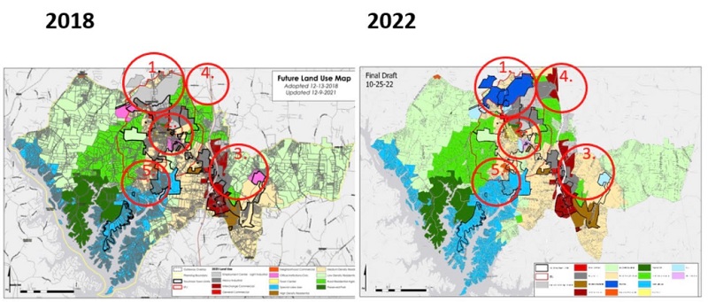
As growth explodes in the Troutman area with thousands of homes planned for already approved developments over the next decade, town staff are finishing up an eight-month effort to revise the town’s Future Land Use Map.
Town Council are scheduled to adopt a final map on December 8 following a 30-day review period for council members and the community.
Town Planner Lynn Hair introduced the latest version of the map to the council for consideration at its November meeting, but members chose to wait until December to allow time to review the changes to the map and to provide transparency for residents.
MAJOR CHANGES
The council asked an advisory committee, chaired by former council member Paul Bryant, to review the entire map but to ensure that four areas were addressed.
The first was to reassess the location of commercial and industrial areas and to create a map that reflects the shift of commercial and industrial development to Interstate 77 interchange areas at Exit 42 and Exit 45.
The committee was also asked to examine the Barium Springs property and how it will fit into the town’s land-use pattern and to assess residential densities in relation to the availability of utilities.
Most importantly, the committee needed to provide the planning staff with an updated map that adequately reflects the goals of the community and that council can use the map in making educated land-use decisions.
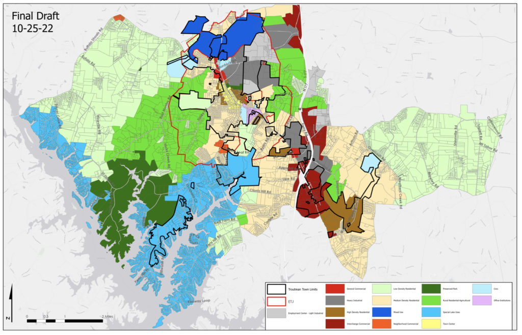
Major changes include:
♦ The Barium property, now the site of the Barium at Wakefield, was moved from Employment Center/Light Industrial to Mixed Use to reflect its change in use as a result of this property sale.
♦ The downtown core along Eastway Drive was changed from Office Institutional to Town Center. The east side of Houston Road moved from Low Density Residential to Medium Density Residential to reflect the density of housing and projected commercial growth on this side of town.
♦ The map was expanded to include the properties that lie between Duck Creek Road and I-77.
♦ Properties and the intersection of Perth Road and State Park Road were brought into the Special Lakes District.
♦ The north side of Murdock Road was moved to light industrial.
The committee also made significant changes to the Land Use Definitions, including:
♦ Adding a definition for Mixed Use.
♦ Separating Office Use and Civic Use, making two individual definitions.
♦ Adding associated zoning districts to land use definitions.
♦ Adding minimum lot size to High Density Residential.
♦ Reducing units per acre in Medium (2-3 units) and High Density Residential (more than 3).
♦ Removing the “clustering” of homes in medium density residential definition. Hair said the next step is to strengthen the UDO to address net density versus gross density in density calculations.
♦ Requiring (instead of “strongly recommends”) that major subdivisions of more than five lots have a variation in lot sizes, housing types, and price points.
♦ Specifying that the single-family dwellings must be detached in low density areas (less than two units per acre).
REVISION PROCESS
At the Council Strategic Planning Session in February, staff first discussed the need to update the Town’s Future Land Use Map even though it had only been four years since the last revision.
Hair said this process, while a little earlier than the traditional five-year cycle, was needed with the increase in development the town is experiencing.
The staff put together a review schedule, with the goal of drafting a new land use map for council consideration in late 2022.
The Advisory Committee began monthly meetings in May to discuss needed changes and the direction of development. They also held two public input sessions and created an online survey asking for community members’ input on their vision for Troutman’s future.
In addition to updating the map, the committee also identified needed changes to the land use definitions and worked to create classifications that more closely fit land use goals of the community.
The committee incorporated community input and created its revised map proposal. At their October 24, meeting, the Planning and Zoning Board reviewed the proposed land use map and recommended approval with two changes.
They asked Hair to make property next to Sanders Ridge low rather than high density residential and to change the property adjacent to the new Weathers Creek High School property, owned by Iredell-Statesville Schools, from high density residential to civic use.
NEXT STEPS
If council approves the map revision, phase two of the update process will focus on updating planning documents, including the Unified Development Ordinance. Staff will finalize the document using the newly created map to reflect its goals.
Hair noted at the council meeting that the staff was also writing UDO text amendments to redefine open space calculations that affect density calculation and to forbid clearcutting of large land tracts.
She also said that all projects now submitted would be considered under the current FLUM, with future projects only subject to the new map if approved by council in December.